Jeju Air – the missing four minutes

Birdstrikes on airliners are not rare, but they don’t usually cause crashes, let alone fatal ones.

The most famous birdstrike accident before the Jeju Air crash at Muan, Korea a little more than a month ago was the “Miracle on the Hudson”, in which a US Airways Airbus A320 climbing away from take-off at New York LaGuardia airport in January 2009 hit a flock of large geese that disabled both engines. What followed captured the public’s imagination to the extent that Hollywood made a movie about it.

When the geese collided with his aircraft, Captain “Sully” Sullenberger made the decision not to attempt a turn-back to land on the runway, but to glide down for a ditching in the Hudson River. All 155 passengers and crew survived the ditching in the river’s freezing water.

Moving forward 15 years, the Korean aviation and railway and accident investigation board (ARAIB) interim report on the 29 December 2024 Jeju Air crash at Muan International Airport has now confirmed that the chain of events leading to the accident also started with a birdstrike on both engines. The Boeing 737-800, on final approach to runway 01 at Muan, ran into a flock of small ducks which caused the engines and the aircraft extensive damage. Details of the extent and nature of the damage have not been established, but it is clear that some of the aircraft’s electrical systems stopped working.

Much more would normally be known at this stage, but the flight data recorder (FDR) and cockpit voice recorder (CVR) stopped operating at the time of the birdstrike (08:58:50 local time), depriving the investigators of extensive data about the last four minutes of the flight that would otherwise have been captured. Simultaneously the aircraft’s ADS-B transmissions that enable the its three-dimensional trajectory to be tracked in real time also stopped, so it will be more difficult to establish the precise course the crew flew in order to line up for the emergency landing they chose to make.

It was at 08:54:43 that Jeju Flight 7C2216, inbound from Bangkok, Thailand, had first contacted Muan Control Tower and received clearance to land on runway 01. If they had not already done so, at that point they would have selected the undercarriage down and set the flaps for landing.

The first hint of the problems the flight was about to face came four minutes later when the Tower warned the Jeju pilots of bird activity ahead (08:57:50). At that point they were about 3nm from their anticipated landing. The electrical failure that stopped the two recorders occurred a minute later at 08:58:50, at which time the aircraft was still 1.1nm away from the threshold of runway 01, according to the ARAIB report.

The crew saw the flock of ducks ahead and below them just before the birdstrike, it seems, so they decided to abandon the approach and carry out a go-around, increasing engine power and starting to climb away. Six seconds later, at 08:58:56 local time, they declared a Mayday emergency, citing a birdstrike, and announcing their go-around, which had now become far more difficult to carry out because of reduced power from the damaged engines.

The report emphasizes that recordings during the last 4min 7sec of the flight are missing. That is the time that elapsed between the electrical failure that stopped the recorders and the moment of the 737’s violent collision with the earth and concrete mound beyond the end of the landing runway in which the ILS localizer antenna array was embedded (09:02:57).

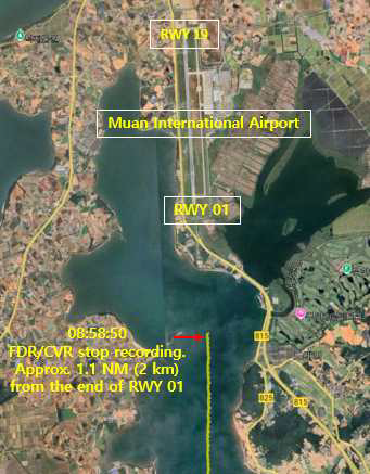
Image from ARAIB interim report

As they initiated their go-around, the pilots felt – and heard – the birdstrike and witnessed a loss of engine thrust just after they had advanced the throttles to climb away. As a part of the go-around drill the crew retracted the undercarriage and selected the flap fully up. There is no recording to confirm this, but they must have done so, as events in the next few minutes make clear.

The attempt to save the flight

The crew knew they had to get the aircraft on the ground fast in case the damaged engines failed completely, but by this time they were losing sight of the runway 01 threshold below the nose as they initiated their go-around, so landing ahead on 01 was no longer an option. Circling back to set up a new approach to the same runway was risky because they might not have sufficient power to maintain height for that long. The ARAIB report says that the last pressure altitude recorded was effectively 500ft (498ft to be precise), and indicated airspeed was 161kt.

At such a point the pilots would want to gain any height and speed they could with the remaining engine power so as to increase their gliding range in the event of total engine failure, and to stay withing gliding range of the runway. So their decision was to fly ahead, then turn through 180deg to land on the same runway but in the opposite direction – that is designated runway 19. Because, during the go-around, they were positioned to the left of runway 01 and parallel to it, they were committing to a right turn to reverse their heading and line up for the approach to 19.

The workload and stress on the pilots at that moment were massive. They did not know how much engine power they would have, or how long they would still have it, so the temptation to turn early to line up on the runway was high. Video of the aircraft’s arrival on runway 19 at Muan shows the aircraft touching down gently with its wings perfectly level, but nearly 2/3rds of the way along the tarmac, travelling very fast with no flaps set, the undercarriage still retracted, and no spoilers deployed.

With the data available at present there is no way of knowing whether the crew failed to get the flap and gear down because of hydraulic problems, or whether the high workload and lack of time made them forget to deploy them. Apart from the failure of electric power to the flight recorders, the investigators don’t know what other problems the pilots faced.

It’s even difficult to work out why an external collision with relatively small birds (Baikal Teals, average weight given as 400g) would cause an electrical supply to fail, unless the undercarriage was still down at the point of birdstrike, leaving electrical wiring and hydraulic tubing in the gear bay vulnerable to impact damage.

Almost all the 181 people on board the Jeju 737 were killed, the only survivors being two cabin crew strapped into their seats in the tail of the aircraft. Everyone on board would still have been alive until the high speed impact with the solid foundations for the ILS localiser antenna array about 200m into the runway overrun, which caused the aircraft to break up and catch fire.

Question for the Korean authorities: what was that obstruction just beyond the Muan runway end?

It will not be long before accident investigators reveal the reasons why the Jeju Air Boeing 737-800 crew felt they had to commit to a flapless, gearless landing on runway 19 at Muan, South Korea. But the reason so many people died was not the landing as such, but the fact that the aircraft (HL8088) collided with a very hard obstruction just beyond the runway end.

That collision broke up the hull and caused a conflagration. What was the obstruction, and why was it positioned on the runway extended centreline only about 200m beyond the runway threshold?

It looks as if it was a concrete anchorage for the Instrument Landing System (ILS) antenna array. ILS antennae are often just beyond runway ends, but they are normally designed to be frangible so any aircraft that collides with them suffers only minor damage. This was hard. Very, very hard.

The sequence of events that led to this accident began with the aircraft approaching runway 01, cleared to land, but the crew elected to go around just after ATC had warned them of a potential birdstrike. It looks as if a birdstrike did, indeed, take place, and the crew declared a Mayday emergency shortly after that.

The crew then elected to land on the same runway but in the opposite direction – on runway 19. This was not much of an issue because the wind was very slight and the visibility was excellent.

But when they returned for the fatal landing on 19 they touched down with no flaps and no landing gear. Why? Perhaps because the birdstrike caused the right engine to fail, and all or some of the hydraulics with it. And the gear and flaps are hydraulically powered.

We don’t know yet, but we will know soon.

Meanwhile the touchdown was as good as a flapless/gearless touchdown could be: wings level, nose not too high to avoid breaking the tail. But being flapless, the airspeed was very high – probably around 200kt.

Look at the video of the landing run. The aircraft slid the full length of the runway with the fuselage, wings and engines substantially intact, and with no fire. It slid over the end still going fast – maybe 70kt or so, but still with no further substantial damage to the structure and no fire.

Then the aircraft hit the obstruction about 150m beyond the hard runway overrun, but until impact it remained substantially undamaged and fire-free. At impact, the hull buckled and broke up, the wing fuel tanks were ruptured and instantly exploded into flames. The wreckage came to rest just beyond the obstruction, near the wire perimeter fence.

If the obstruction had not been there, the aircraft would have slid through the antenna array, across the level ground beyond it, and through the wire perimeter fence. It would have come to rest with most – possibly all – those on board still alive.

We will soon find out the whole truth about why the landing took place as it did. But because the accident killed all on board except two of the cabin crew, those answers will be almost academic. The question to answer is: what was that obstruction, and why it was there?

Airlines: the pre-Truth industry

Airline pilots today are obliged to steer their machines according to an instrument discovered in the earth’s Iron Age: the magnetic compass. Ships’ commanders only use that these days if all else fails.

By modern navigation standards the magnetic compass is not an accurate device. An aviator flying along a magnetic meridian toward either the North or South Magnetic Pole flies “a wiggly track” according to the Geomagnetism Team of the British Geological Survey. The pilot’s magnetic compass may display a constant heading, but the aircraft relying on it follows the gently wandering vagaries of the earth’s dipolar magnetic field.

In 2011 a Boeing 737 suffered a fatal crash on approach to land because of the artificially-induced complexities of a navigation system based on Magnetic North in a digital era (detail later). All four crew and eight of the 11 passengers were killed.

Modern aviation navigation can be conducted using a phenomenally accurate, multi-sensor system orientated to the earth’s spin axis, with reliable integrated backups. But in fact it’s compromised by the decision to continue using a legacy system of orientation based on the earth’s ever-changing magnetic field.

This dependency on steering by the earth’s dipolar magnetic field when technology provides far better alternatives is enforced by institutions like the International Civil Aviation Organisation and the International Air Transport Association which are content with the status quo.

For the time being at least.

ICAO’s maritime sibling, the International Maritime Organisation, approved navigation by True North/South beginning in the late 1970s, and now it is universal for all but a few coastal mariners who choose not to use GPS backed up by inertial navigation systems (INS). Now the IMO is in the final stages of implementing standards for what it calls “e-navigation”, its way of describing the use of the best available integrated digital, satellite and other technology, plus best practice, to achieve the most accurate and reliable navigation at sea, all with the earth’s spin axis as the directional orientation reference.

ICAO itself, on the other hand, commented recently: “This issue [navigation by True North] is not on our work programme at present.”

Asked for a comment on the situation, the UK CAA said: “We understand the issue, and with the increased use of GPS etc., moving to True North does make more sense. Also as more aerodromes look to formalise GNSS (global navigation satellite systems) approaches the logic is clear.”

So why not adopt True North? It’s not the CAA’s job to make this decision (rather it’s for ICAO and EASA), but the CAA slightly apologetically offered this explanation on behalf of the international aviation establishment: “If you were starting from a blank sheet of paper with the technology available today, you would select True North. But aviation started with magnetic from the outset. The infrastructure supporting aviation is also based on magnetic, including VORs, runway directions, approach procedures, radar etc.”

ICAO and IATA argue that navigation by magnetic track still works, so there’s no need to face the effort and cost of moving to an orientation system based on Earth’s spin axis (True North/South) despite the fact that the cost of changeover would be one-off.

Maintaining the existing system, which requires regular updating as the earth’s two magnetic poles constantly migrate relative to the geographic North and South Poles, has a continual cost, but that’s apparently fine because it’s built in to the system’s budget, so no new decisions need to be made.

Magnetic navigation is fine as a backup system – and nobody doubts that every aircraft will continue to carry a standby magnetic compass in the cockpit as long as manned flight lasts. The IMO requires all ships to have a magnetic compass, but to steer by a system using True North.

Maps and charts are oriented according to the earth’s spin axis – True North/South. This is also the orientation datum programmed into the firmware of the aircraft flight management computers (FMC). They have to convert their orientation information to Magnetic to pass it to the avionics displays, unless the pilots choose to select True, which, of course, they can. But air traffic management protocol requires them to use Magnetic when operating under instrument flight rules (IFR).

Air traffic controllers still pass magnetic headings for pilots to steer for procedures and traffic separation purposes. Pilots still navigate by adopting Magnetic headings which are actually converted from True by the FMS and shown on their compasses in the primary flight display/navigation display.

The FMS does this by applying a “variation” between Magnetic and True that was embedded in the firmware when the system was set up.

This variation value needs to be updated regularly, but it rarely is, despite the fact that, in the last 40 years the rate of migration of the Magnetic North Pole (MNP) has accelerated dramatically. FMS software is easily updated, but firmware is more of a problem.

In fact the surface position of the MNP is forecast to reach its closest point relative to the Geographic North Pole (GNP) in 2020 (approximately 87N 170E), and then it will continue moving tangentially past the GNP toward Russia’s north coast. Therefore the so-called magnetic heading most aircraft are flying is inaccurate because the variation value – in many fleets – has not been updated since the FMS was new.

THE RESULTING FATAL CRASH

As a result of this built-in disparity, in 2011 an airliner fatally crashed into high ground because the pilots were confused by an inaccurate compass heading.

On 20 August 2011 the crew of the Bradley Air Services Boeing 737-210C (C-GNWN) were attempting an instrument landing system (ILS) approach to the airport at Resolute Bay, Nunavut, in Canada’s far northern islands, somewhat closer to the Magnetic North Pole than most aviators usually get to fly. The airfield and approach charts – and therefore the procedures – show True North for orientation. This is customary in polar regions because the magnetic field lines close to the Magnetic North Pole have a strong vertical component, so the lateral strength of the field reduces. Meanwhile the variation can be enormous.

The Resolute Bay ILS approach that day was to runway 35T, the localiser orientated to 347degT. The magnetic variation at Resolute Bay at the time was 28degW.

The autopilot was initially set to VOR/LOC Capture, and the compass system set to True, but according to the Transportation Safety Board of Canada (TSBC) report there was a compass error. The captain was flying 330degT according to the heading on his horizontal situation indicator (HSI), perceiving the intercept angle to be 17deg from the right of the localiser (347T).

The report explains: “However, due to the compass error, the aircraft’s true heading was 346deg. With 3deg of wind drift to the right, the aircraft diverged further right of the localiser. The crew’s workload increased as they attempted to resolve the ambiguity of the track divergence, which was incongruent with the perceived intercept angle and expected results.”

resolute-bay-approach-2

Diagram from TSBC report

This is what happens when pilots don’t know what to believe, and in a region where there are three Norths – Magnetic, True, and Grid (the latter for local charts), confusion is the default when things don’t proceed as expected.

The crew were indeed confused and decided to abandon the approach, but just as they were initiating the go-around the 737 flew into a snow-covered rocky hilltop about a mile east of the airfield. It didn’t help that the aircraft was fitted with an old fashioned – rather than an enhanced – ground proximity warning system, and that the crew were under additional pressure because they began the descent well above the glideslope.

Spurred by this event, at ICAO’s Air Navigation Conference in November 2012 Nav Canada proposed that aviation should stop using magnetic references and use only directional orientation relative to the Geographic North Pole.

This makes particular sense for any country – like Canada – with territories that approach the arctic or antarctic regions, who are forced to use True close to the magnetic poles, but it would also work perfectly worldwide. But the Montreal-headquartered ICAO has still not put the issue on its “to do” list.

Now, however, with more flights than ever transiting the Arctic ocean on routes between North America and South East Asia or India, steering by Magnetic North makes little sense, although it just happens that the Magnetic North Pole is now migrating closer to the Geographic North Pole than it has ever been in recorded history.

That imminent closeness of the two North Poles is used by the pro-True lobby to suggest this is a natural time to change, because the changes required will be the smallest they have ever been. But it is change itself that presents the one-off cost, and which demands scarce human resources to organise it, not the mathematical size of the variation between Magnetic and True.

The following rather simplified chart shows that the advantages – in today’s world – of Magnetic are few, and the disadvantages many and compelling, while the advantages of True are powerful and its disadvantages relatively trivial.

mag-vs-true-3-2

Maybe at present there is no actual urgency to adopt True North as aviation’s navigation lodestar, but industry voices on the subject are muted, as if it is bad form to step out of line.

A major European airline, not alone in its beliefs, has a compelling and detailed presentation on the subject, in which it concludes : “Transition from magnetic to true reference is unavoidable. The transition phase will need further studies in order to maintain the safety objectives. Time is ripe to start the transition process.” But the carrier was not prepared to break cover.