Much of the world’s fleet of about 11,000 Airbus A320 series aircraft – the most popular airliner in the world according to sales – are affected by a current emergency airworthiness directive from the European Union Aviation Safety Agency and the US Federal Aviation Administration requiring that operators modify their aircraft control software to make it more resistant to the effects of solar radiation.
This followed a sudden loss of height in the cruise involving a JetBlue A320 en route from Cancun, Mexico to Newark, USA on 30 October. Solar radiation is believed to have been responsible for corrupting the data in one of the aircraft’s flight control computers causing the sudden height loss – which injured several passengers. Recovery action by the pilots ensured the aircraft diverted safely to Tampa, Florida.
Most younger A320s need only a quick software patch to harden the microchip resistance in their flight control computers against particularly vigorous bursts of solar radiation, but nearly a thousand of the oldest aircraft may need to change the units.
Solar radiation is known to be able to interfere with GPS signals, radio communication, inertial navigation systems, autopilot, and full-authority digital engine controls (FADEC), although incidents are rare. A mysterious sudden pitch-down by a Qantas A330 in the cruise over Western Australia in October 2008 is now reckoned to have been caused by corrupted data from an air data inertial reference unit (ADIRU) that may have been subject to solar radiation damage.
All aircraft are more vulnerable than suface vehicles to solar radiation effects because, at high altitude, there is less atmospheric attenuation of the sun’s electromagnetic energy. Polar flights are particularly vulnerable because the earth’s magnetic field provides less shielding and the troposphere is at a lower altitude there.
A320 series aircraft have three three flight control primary computers (FCPC), two flight control secondary computers (FCSC), and a flight augmentation computer, all of which provide considerable systems redundancy, plus a cross-checking capability to detect and correct anomalous data.
The UK Civil Aviation Authority said today that there had been virtually no disruption to flight schedules because airlines were so quick to apply software fixes.
1 December 2025: a statement from Airbus on this date claimed that only about 100 A320 series aircraft remained to receive the softwear hardening required by EASA an the FAA.
Pilots set their desired heading using a magnetic compass, don’t they?
Well, mostly, no.
In a few years, practically none will do that. That’s the subject of this page today, because change is in the pipeline.
A traditional standby magnetic compass
Aviation has inherited a legacy from navigators’ historic reliance on Planet Earth’s magnetic field for direction: by international agreement, aviators still use the position of the geomagnetic north pole as their heading reference, just so that all pilots fly by the same rule book. Very few, however, still use a magnetic compass to determine which direction to point their aircraft.
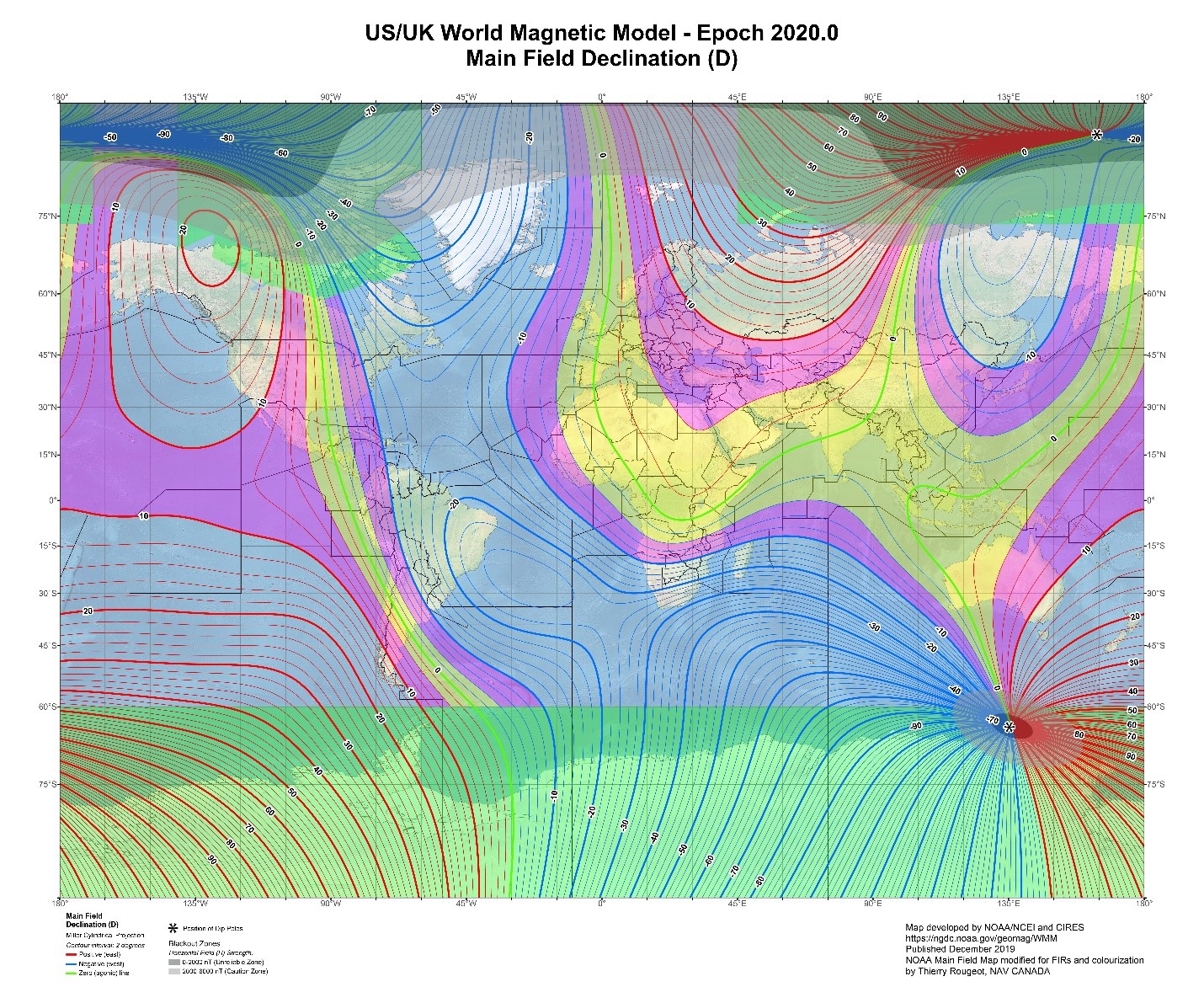
Magnetic compasses don’t point to True North, just somewhere near it. In fact they point to “Magnetic North”, whose present position is on the north-eastern coast of Ellesmere Island in Canada’s far northern territories, about 500nm from True North. The difference exists because the Earth’s subterranean magnetic dipole is inclined about 9.5deg to its rotational axis.
To add to the confusion, the North and South Magnetic Poles’ surface positions are not static, but very slowly – and unpredictably – drifting.
The ultimate geographic heading reference – for charts and for air navigation – is True North, 90N Latitude, because Earth’s rotational axis is a constant and latitude/longitude is arranged around that. So any aviator using a magnetic compass, or other systems for detecting the horizontal component of earth’s magnetic field, has periodically to update the aircraft’s heading reference systems for magnetic polar drift.
Also – during long flights – the local angular difference between where the aircraft’s magnetic compass points and where True North actually is varies, especially during a very long flight. Of course, in aircraft with sophisticated flight management systems (FMS), many of these variables are automatically compensated, but unless the data in the FMS is regularly updated, some of the compensations applied will be wrong.
The areas shaded in yellow and magenta are the parts of the world where the difference between True and Magnetic North is +/- 10deg or less. In all the rest, the difference is greater. The green shaded areas are the regions where the difference is so great that Magnetic North is unusable, so True North is used anyway.
This has to change, because there are better ways of navigating now. For professional pilots flying modern aircraft, the use of Mag North as a heading reference ought really to be history, but the process of agreeing – globally – when and how to conduct the transition to a True North heading reference has been slow. Getting all the world’s nations to agree to synchronise such an exercise is much more an effort of political and administrative will than a technical challenge.
If you have already been confused by the above description of the inconsistencies in using the Earth’s wandering magnetic field as a heading reference, you are likely to find that when you consider instead the modern alternatives, they sound comparatively simple – even if the enabling technology is sophisticated.
The modern alternatives to navigation by Magnetic North are use of the now-familiar GPS-type satellite navigation systems, combined with modern inertial navigation systems, also known as inertial reference systems (IRS).
When you turn on your car GPS, it knows the position of your car, but doesn’t know which way it’s pointing until you start moving; then it immediately detects the direction and speed of travel.
Today’s IRS are, effectively, incredibly sensitive 3D accelerometer systems, and the data they produce is fed to computers for analysis. The combined platforms can be an attitude and heading reference system (AHRS, which also has magnetic input) or a pure IRS. When an IRS is switched on, it doesn’t know its position, but it senses the earth’s rotation, and from that works out the orientation of Earth’s axis, and therefore the direction of True North. The combination of the GPS aircraft position data and the IRS directional reference provide all the data required for highly accurate navigation.
What of backup, just in case things go wrong?
First of all, the system – in advanced aircraft – is duplicated or triplicated. If GPS fails or is locally jammed, the IRS/AHRS – which is completely autonomous – remains highly accurate as a dead-reckoning navigation system until GPS is regained and position can be updated.
Canada, in whose far northern territory the geomagnetic North Pole is located, has for decades required that all navigation in its northernmost airspace is conducted using the True North heading reference. Given its practical experience in this science, Canada has taken the lead in a relatively new but expert multinational body called the Aviation Heading Reference Transition Action Group (AHRTAG), which coordinates with ICAO.
AHRTAG reckons the changeover from Magnetic to True – now given the shorthand title Mag2True – should be in operation by March 2030.
If this subject has piqued your interest and you are curious to explore the Mag2True journey in greater detail, a description of the transition plans will first appear in Flight International’s November issue, out at the end of this month, and on FlightGlobal.com.